|
|
|
|
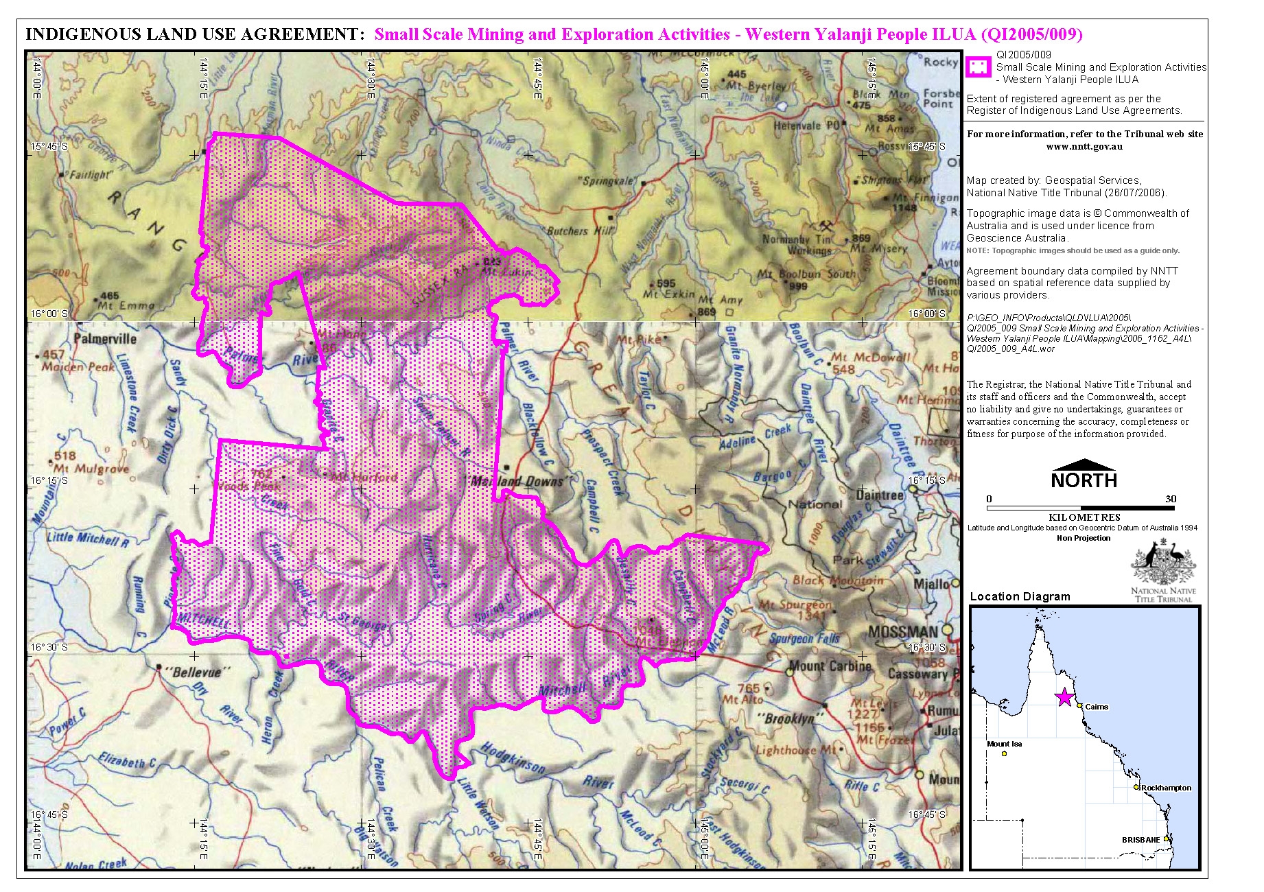
Small Scale Mining and Exploration Activities - Western Yalanji People Indigenous Land Use Agreement (ILUA) | | Date: | 6 June 2006 | | | Sub Category: | Indigenous Land Use Agreement (ILUA) (Native Title Act) | | Place: | Far North Queensland | | State/Country: | Australia | | The extract of the ILUA from the Register of Indigenous Land Use Agreements describes the area covered by the agreement as follows:
'Commencing at the intersection of the left bank of the McLeod River and the left bank of the Mitchell River;
thence westward along the southern (left) bank of the Mitchell River to its intersection with the boundary of Lot 285 on SP108034;
thence along the northern boundary of Lot 285 on SP108034 in a south-easterly direction to its intersection with the centreline of the Hodgkinson River;
thence along the centreline of the Hodgkinson River generally in a south-westerly direction to the intersection with the southern (left) bank of the Mitchell River;
thence generally in a north-westerly direction following along the left bank of the Mitchell River to its intersection with the right bank of Pinnacle Creek;
thence by a line northerly to a point on an unidentified track at coordinate 144.218333ş E and 16.447777ş S;
thence generally in a northerly direction along the centreline of this track to its intersection with the southern boundary of Native Title Claim QUD3/05 (Yalanji #7); as registered at 2 February 2005;
thence generally in an easterly direction along the southern boundary of Native Title Claim QUD3/05;
thence generally in a northerly direction along the boundary of Native Title Claim QUD3/05;
thence generally in an easterly direction along the boundary QUD3/05 to its intersection with Granite Creek;
thence generally in a northerly direction along the north-eastern boundary of Native Title Claim QUD3/05 to its most northerly point;
thence following the boundary of QUD3/05 generally in a south-westerly and southerly direction to the left bank of the Palmer River (which is coincident with the boundary of QUD3/05);
thence west, north-westerly along this boundary to the south west corner of Lot 1 on CP907719;
thence generally in a northerly direction along the westernmost boundary of Native Title Claim QUD6008/99 (Western Yalanji #4) as registered at 16th April 1999, which is coincident with the western boundary of Lot 1 on CP907719 and the western boundary of Lot 1 on CP825797 and following along this boundary to its north-western corner;
thence generally in an east, south-easterly direction along the northern boundary of Native Title Claim QUD6008/99 to a corner that intersects with the northern boundary of Lot 1 on CP825797 and Lot 351 on RP835609;
thence following along the boundary of Native Title Claim QUD6008/99 generally in a south-easterly direction coincident with the north-eastern boundary of Lot 66 on SP161906;
thence along this boundary to its intersection with the boundary of Lot 6 on SP113648;
thence generally in a south, south-westerly direction along this boundary to its intersection with the boundary of Lot 2 on CF313 encompassing the town of Lakeland Downs;
thence following the eastern boundary of Native Title Claim QUD6008/99 in a southerly direction, coincident with the eastern boundary of Lot 66 on SP161906 to its intersection with the Cape York Land Council’s (CYLC) southern boundary;
thence generally easterly along the southern boundary of the CYLC boundary, to its intersection with the northern most point of Lot 191 on DA805299;
thence along the northern boundary of lot 191 on DA805299 to its intersection with Spencer Creek;
thence generally in a south-westerly direction along Spencer Creek to its intersection with the left bank of the McLeod River;
thence along the left bank of the McLeod River back to the point of commencement.
Excluding the areas specified in paragraph 2 of the determination of native title by the Federal Court of Australia on 28 September 2004 in Western Yalanji or “Sunset” peoples v Alan & Karen Pedersen & Ors [1998] 1269 FCA specifically Area E (being ML 20028) and open roads, dedicated roads and roads legally constructed for public use as marked on the map in Schedule 1 to the determination headed Plan of the Determination Area.'
The ILUA area is located with the local government areas of the Cook Shire Council and the Mareeba Shire Council. | | Legal Status: | Registered with the National Native Title Tribunal | | | Legal Reference: | National Native Title Tribunal File No.
QI2005/009 | | | Subject Matter: | Compensation | Exploration | Mining and Minerals | Native Title | | Summary Information: | | |
The Small Scale Mining and Exploration Activities – Western Yalanji People Indigenous Land Use Agreement (ILUA) was agreed between the State of Queensland, Rose Colless, Rodney Riley, Desmond Brickie, Thomas James Mitchell, William Steven Brady, Dell Riley, Graham Brady, North Queensland Land Council, Western Yalanji Aboriginal Corporation and North Queensland Miners Association on 30 September 2005. It was registered with the National Native Title Tribunal on 6 June 2006.
The purpose of the ILUA is to provide consent for a range of ‘future acts’ relating to the grant and exercise of prospecting permits, exploration permits, mineral development licences, mining claims and mining leases. | | Detailed Information: | | |
The Western Yalanji people agree that the State of Queensland may grant certain prospecting permits, exploration permits and mineral development licences in relation to the ILUA area. These will contain certain ‘native title conditions’ that must be complied with, and will also contain compensation provisions.
The ILUA stipulates certain conditions about the size of the area that these rights and interests relate to, including that a mineral development licence cannot be granted for an area of land that comprises 50 hectares or more, and that the holder of that licence may not hold more than 150 hectares of land under a mineral development licence in Queensland at any one time.
The Western Yalanji people also consent to the grant of mining claims and mining leases provided that, among other things, the grantee company has complied with the ‘alternative procedure for mining interests’ and has paid the required amount of compensation.
The ILUA also provides for consent to renew any existing mining interests and exploration permits.
These permits, claims, licences and leases are classified as ‘future acts’. Under the Native Title Act 1993 (Cth) any activity, such as a grant of land, that may affect native title rights is defined as a ‘future act’ and must comply with the future act provisions of the Act in order to be valid. The parties to this ILUA agree that the right to negotiate provisions of the Act do not apply, as the alternative consultation provisions are to be followed instead.
The ILUA further states that if the Federal Court determines that native title does not exist in relation to any area that is the subject of this ILUA (‘extinguishment area’), the ILUA will not apply to that extinguishment area. | |
|
|
|
|

 Small Scale Mining and Exploration Activities - Western Yalanji People Indigenous Land Use Agreement (ILUA) Map - (