
 Print this page Print this page | ||
West MacDonnell National Park Indigenous Land Use Agreement (ILUA) | ||
| Date: | 3 October 2005 | |
| Sub Category: | Indigenous Land Use Agreement (ILUA) (Native Title Act) | |
| Place: | West of Alice Springs | |
| Click this link to search this location with google maps | ||
| State/Country: | Northern Territory, Australia | |
| Click this link to search this location with google maps | ||
| The ILUA area is located west of Alice Springs in the MacDonnell Ranges. The extract of the ILUA from the Register of Indigenous Land Use Agreements describes the area covered by the agreement as follows: 'The Park means; (1). Part of Simpson's Gap National Park: All that parcel of land near Simpson's Gap in the Northern Territory of Australia containing an area of 30690 hectares more or less being the whole of Northern Territory Portion 247 more particularly delineated on Compiled Plan 3630 lodged with the Surveyor General, Darwin. (2). Part of Simpson's Gap National Park: All that parcel of land near Simpson's Gap in the Northern Territory of Australia containing an area of 259 hectares more or less being the whole of Northern Territory Portion 528 more particularly delineated on Survey Plan A191 lodged with the Surveyor General, Darwin. (3). Serpentine Gorge Nature Park: All that parcel of land near Owen Springs in the Northern Territory of Australia containing an area of 518 hectares more or less being the whole of Northern Territory Portion 779 more particularly delineated on Survey Plan OP1333 lodged with the Surveyor General, Darwin. (4). Glen Helen Gorge Nature Park: All that parcel of land near Glen Helen in the Northern Territory of Australia containing an area of 386 hectares more or less being the whole of Northern Territory Portion 831 more particularly delineated on Survey Plan A322 lodged with the Surveyor General, Darwin. (5). Ormiston Gorge and Pound National Park: All that parcel of land near Ormiston Gorge in the Northern Territory of Australia containing an area of 4655 hectares more or less being the whole of Northern Territory Portion 910 more particularly delineated on Survey Plan OP1331 lodged with the Surveyor General, Darwin. (6). Ellery Creek Big Hole Nature Park: All that parcel of land near Hermannsburg in the Northern Territory of Australia containing an area of 1766 hectares more or less being the whole of Northern Territory Portion 936 more particularly delineated on Survey Plan OP1369 lodged with the Surveyor General, Darwin. (7). Redbank Gorge Nature Park: All that parcel of land near Glen Helen in the Northern Territory of Australia containing an area of 1295 hectares more or less being the whole of Northern Territory Portion 951 more particularly delineated on Survey Plan OP1362 lodged with the Surveyor General, Darwin. (8). Alice Valley: All that parcel of land near Owen Springs in the Northern Territory of Australia containing an area of 16890 hectares more or less being the whole of Northern Territory Portion 3290 more particularly delineated on Survey Plan S86/95 lodged with the Surveyor General, Darwin. (9). Chewings Range Extension: All that parcel of land near Hamilton Downs in the Northern Territory of Australia containing an area of 21100 hectares more or less being the whole of Northern Territory Portion 3472 more particularly delineated on Survey Plan S88/13 lodged with the Surveyor General, Darwin. (10). Part West MacDonnell National Park: All that parcel of land near Glen Helen in the Northern Territory of Australia containing an area of 72290 hectares more or less being the whole of Northern Territory Portion 3719 more particularly delineated on Survey Plans S89/36A and S89/36B lodged with the Surveyor General, Darwin. (11). Part West MacDonnell National Park: All that parcel of land near Narwietooma in the Northern Territory of Australia containing an area of 13480 hectares more or less being the whole of Northern Territory Portion 4116 more particularly delineated on Survey Plan S92/29A lodged with the Surveyor General, Darwin. (12). Part West MacDonnell National Park: All that parcel of land near Milton Park in the Northern Territory of Australia containing an area of 40280 hectares more or less being the whole of Northern Territory Portion 4156 more particularly delineated on Survey Plan S92/64 lodged with the Surveyor General, Darwin. (13). Areas previously set aside for Living Areas: All that parcel of land near Glen Helen in the Northern Territory of Australia containing an area of 810 hectares more or less being the whole of Northern Territory Portion 4727 more particularly delineated on Survey Plan S94/69 lodged with the Surveyor General, Darwin. All that parcel of land near Glen Helen in the Northern Territory of Australia containing an area of 2480 hectares more or less being the whole of Northern Territory Portion 4797 more particularly delineated on Survey Plan S95/31 lodged with the Surveyor General, Darwin.' The ILUA area falls within the Central Remote Regional Council ATSIC region. | ||
| Legal Status: | Registered with the National Native Title Tribunal | |
| Legal Reference: | National Native Title Tribunal No.: DI2004/029. | |
| Subject Matter: | Native Title | Environmental Heritage | Land Transaction | Land Management | Land Use | |
| Summary Information: | ||
| The West MacDonnell National Park Indigenous Land Use Agreement (ILUA) was signed by the Central Land Council, the Northern Territory Government and the native title parties for the purpose of granting the Park as Aboriginal land under the Aboriginal Land Rights (Northern Territory) Act 1976 (Cth) (ALRA). This ILUA is one of 31 agreements signed over parks and reserves in the Northern Territory. The agreements were developed following the High Court's decision in Western Australia v Ward, which found that the Keep River National Park had not been properly established. In response, the Northern Territory Government pursued ILUAs and joint management agreements to resolve tenure disputes and management of the parks. These agreements were negotiated from 2002 to 2005, during which time the Parks and Reserves (Framework for the Future) Act 2003 (NT) was also passed. These arrangements aim to settle all native title issues in Northern Territory national park areas. | ||
| Detailed Information: | ||
| The West MacDonnell National Park is listed under Schedule 1 of the Parks and Reserves (Framework for the Future) Act 2003 (NT). This lists those areas for which tenure and management changes will occur in line with new arrangements for Northern Territory National Parks. Under the ILUA, the parties consent to the granting of the Park as Aboriginal land under the ALRA and to facilitating the future development of the Park in compliance with the ALRA. The purpose of the ILUA is to satisfy the condition set out in s 10(1)(b) of the Parks and Reserves (Framework for the Future) Act 2003 (NT) and to otherwise deal with native title issues in respect of the scheduling of the Park as Aboriginal land under the ALRA. Even though the land is returned to traditional owners, it will be leased back to the Northern Territory Government for a minimum of 99 years. The land must be used for parks. Agreements outlining joint management of the park by Indigenous groups and the Northern Territory Parks and Wildlife Service will be developed. | ||
 West MacDonnell National Park Indigenous Land Use Agreement (ILUA) Map - (
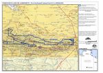
| ||||
| ||||
|
Was this useful? Click here to fill in the ATNS survey