 Print this page Print this page | ||
Western Yalanji and Cook Shire Council Indigenous Land Use Agreement (ILUA) | ||
| Date: | 18 May 2006 | |
| Sub Category: | Indigenous Land Use Agreement (ILUA) (Native Title Act) | |
| Place: | North-west of Cairns | |
| Click this link to search this location with google maps | ||
| State/Country: | Queensland, Australia | |
| Click this link to search this location with google maps | ||
| The ILUA area is situated within the Cook Shire Council, and the Cairns & District and Peninsula Regional Councils.
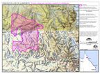
The extract of the ILUA from the Register of Indigenous Land Use Agreements describes the area covered by the agreement as follows: The ILUA Area comprises an area commencing at the northernmost western corner of Lot 1 on Plan CP825797, being a point on the northern boundary of native title determination application QG6008/99 Western Yalanji People 4 (QC99/12) and extending generally easterly and generally southeasterly along northern boundaries of that lot to the northern boundary of Lot 66 on Plan CF844107 (Bonny Glen Pastoral Holding); then generally southeasterly and generally southwesterly along northern and eastern external boundaries of that lot to the northernmost corner of the southwestern severance of Lot 2 on Plan CF13; then generally northerly, generally easterly, generally southerly and generally westerly along western, northern, eastern and southern external boundaries of that lot to again the eastern boundary of Lot 66 on Plan CF844107 (Bonny Glen Pastoral Holding); then generally southerly again along eastern boundaries of that lot to a southern boundary of Cook Shire; then generally southerly along that shire boundary to a southern boundary again of Lot 66 on Plan CF844107 (Bonny Glen Pastoral Holding); then westerly again along southern boundaries of that lot to again a southern boundary of Cook Shire; then generally westerly along southern boundaries of that shire to again a southern boundary of Lot 66 on Plan CF844107 (Bonny Glen Pastoral Holding); then westerly again along southern boundaries of that lot to the northeastern corner of Lot 1 on Plan CF14, being an eastern boundary of native title determination application QG6089/98 Western Yalanji People 3 (QC98/39); then southerly along the eastern boundary of that lot to again a southern boundary of Cook Shire; then generally westerly again along southern boundaries of that shire to the eastern boundary of Lot 233 on Plan PH1796 (Mount Mulgrave Pastoral Holding), being a point on the western boundary of native title determination application Q6003/01 Western Yalanji 5 (QC01/3); then northerly along eastern boundaries of that Lot to its easternmost point; then easterly to a western boundary again of Lot 66 on Plan CF844107 (Bonny Glen Pastoral Holding) at the northeastern corner of native title determination application Q6003/01 Western Yalanji 5 (QC01/3) being the southwestern corner of the Parish of Uhrstown and the northwestern corner of the Parish of Nangee; then generally northerly along western boundaries of that lot to a southern boundary again of Lot 1 on Plan CP825797; then generally southwesterly along southern boundaries of that lot to the northeasternmost corner of Lot 1 on Plan CP907719 (Palmer River Resource Reserve); then generally southerly and generally westerly along eastern and southern external boundaries of that Reserve to a southwestern corner of the northeastern severance of Lot 7 on Plan CF12; then generally westerly and generally northerly along southern and western external boundaries of that lot to again Lot 1 on Plan CP907719 (Palmer River Resource Reserve); then generally westerly and generally northerly again along southern and western external boundaries of that Reserve to again a western boundary of Lot 1 on Plan CP825797; then generally northerly along western external boundaries of that Lot back to the commencement point. The Agreement also covers land and waters within the Mining Leases 20282 and 20257 and Mining Claims 20074 and 20075 (as covered by native title determination application QG6008/99 Western Yalanji People 4 (QC99/12)). | ||
| Legal Status: | Registered with the National Native Title Tribunal | |
| Legal Reference: | National Native Title Tribunal No.: QI2004/064 | |
| Subject Matter: | | Native Title | |
| URL: | http://www.nntt.gov.au/Indigenous-Land-Use-Agreements/Search-Registered-ILUAs/ILUA%20Register/2004/QI2004.064/ILUARegisterExport.pdf | |
| Summary Information: | ||
| The Western Yalanji and Cook Shire Council Indigenous Land Use Agreement (ILUA) was agreed between Rodney Riley, Desmond Brickie, Thomas James Mitchell, Dell Riley, Graham Brady, William Steven Brady and Cook Shire Council and was registered on the Register of Indigenous Land Use Agreements on 18 May 2006. The purpose of the ILUA is to provide consent for the resolution of certain issues between the native title rights and interests of the Western Yalanji and the infrastructure interests of the Cook Shire Council. It also establishes a process regarding the doing of Future Acts. | ||
| Detailed Information: | ||
| The parties to the ILUA consent to the doing of acts related to the following: The Cook Shire Council may, by following the set process, apply to make the construction of infrastructure that has not been approved an Approved Future Act. The parties consent to the doing of Approved Future Acts and agree that the right to negotiate provisions of the Native Title Act 1993 (Cth) do not apply to such acts. | ||
| ||||
| ||||
|
Was this useful? Click here to fill in the ATNS survey

 Western Yalanji and Cook Shire Council Indigenous Land Use Agreement (ILUA) Map - (